Lower Williamson River Gorge Hike (or Walk?)
Turn off Hwy 97 to Collier State Park Campground and the road immediately forks, take the road to the left. In about 1.5 miles the road will fork again, stay left, then take the first dirt road to the left. You'll see the rock bluffs ahead. The road will turn to the right, and head east running parallel to the bluffs. Continue on that road until it dead ends at the entrance to the lower gorge. There is moderate vehicle clearance.
Upper Williamson River Gorge -
No Doubt this is a hike.
-
Heading north from Chiloquin on Hwy 97, continue past the entrance to Collier State Park. You'll drive over a bridge and up a hill; about 5 miles after the bridge, you'll see a sign that says "Deer next 26 miles". Immediately after the sign you'll see 3 dirt roads on the right. Take the middle one. Follow it east, don't take any turnoffs; look for a big pine clearing on the bluff overlooking the gorge. When you arrive at the bluff overlooking the gorge, find a place to park and hike down into the gorge. The hike in its entirety is 5 miles. Note: If you're considering the middle gorge it all but tunnels and is nearly impassable. There is moderate vehicle clearance
Hiking without Trails.
-
Both the following hike on the Badlands and the hike on the Upper Gorge of the Williamson River are without trails, and are not in the least tame. One should only attempt them if one realizes this. That even the most difficult hike in the Umpqua Waterfall Tour is not like these. But they're not hard either. It's just hard to explain. I'll give an example. One summer Brad had a family very excited to come and stay at the retreat. They were staying in the elfin tree house and were excited about every aspect of their trip. They planned on hiking with their children and wanted to get into nature.
They stayed one night. That's all. I emailed them and asked why. She sent back a segment of Brad's advertising which spoke of hiking. From that I assumed she didn't think there was any place to hike around the retreat. I wished she had spoke to me of this before leaving. Being a city girl myself, I would have understood. But certainly around the retreat there are many places to hike. Just cross the road and take off up the mountain. I have wandered all over that mountain, but I do remember the first time I came down here Brad said to me, "You don't even go to the river." Well, between me and the river were forests: Big old Ponderosa Pine Forests. Mind you, I am not fearful. I am daring, but I was not used to just taking off in the woods. So when I say these are HIKES, please try to understand what I mean. Especially for the Badlands.
Badlands, a unique hike (more of a rock climb) for the adventurous
-
Make your way into Chiloquin from Hwy 97. You'll see the sign, but you need only turn east at Winema Real Estate and follow the road as it turns round into Chiloquin. Once in Chiloquin, turn left right after the gas station. That's Sprague River Hwy. (One sign calls it a road, another calls it a highway. Just know it's Sprague River whatever ...) Not long after the 5 mile marker you'll see a left turn lane just before a bridge. Turn left. This is rangeland. Saddle Mountain will be southeast on the right, but it won't appear as a saddle yet. Shortly after re-entering forest-lands there will be a side road to the right; it's marked by two vertical markers: one marked 2000, one marked 2010. Note them, but don't turn yet. Continue several miles until the mountain looks like a saddle; the Badlands form the eastern foot of this mountain. They might look somewhat like a mesa or a tableland. Note their appearance for this is where you want to go. Turn and return to the first gravel/dirt road after the first open rangeland noted earlier: 2000/2010. Turn left on this road; don't turn off on any side roads, but continue heading southeast until you arrive at the area as seen and noted earlier from the highway prior to turning around. There is no trail. One must simply climb. Hike to the top of the tablelands. It's volcanic with plenty of footholds. It's not rock climbing. Once you reach the top, just wander to your heart's content. It is possible to walk a gradual descent through aspen forests and green grass to return to rangeland once again. Just wander until you find it. When you make your way down to the old homestead, walk around the base of the mountain towards your car. You won't see your car, you will just have to have a sense of direction as to where you left your car:) This hike is for the sure-footed and fit, as well as, adventurous. Moderate vehicle clearance may be required.
Kimball Creek State Park and Fort Creek Area
This is easy. Just a pretty place to walk. :) Drive north on Crater Lake Hwy through the rangelands of Klamath Basin. If you're coming from west of Crater Lake, you would drive south and east after leaving the road that takes you up to the lake and the rim drive. Follow the Crater Lake Hwy until you see a sign for Kimball Creek State Park on a curve. Follow this sign and you will arrive in Kimball Creek State Park, but if you want to go to the headwaters of Fort Creek, turn right on the first dirt road, which will "T" at Fort Creek. Turn left on the "T" then take the next road going right, and rising up a hill then down, park alongside Fort Creek. Walk upstream on the path a short distance to the headwaters. Note: This road can be very dusty in late summer, but you won't have far to drive. Some vehicle clearance may be needed.
I have a short and somewhat funny story about a city girl's first summer living in the woods. Brad took me to Fort Creek. We drove around on different roads out there until Brad saw a hill covered in small pieces of slate, and he said he'd never climbed that before. So we did. The slate was so deep I had to bury my toes to make certain I wouldn't slide back. When we got to the top, I saw a trail. I looked at it and wondered who could have been walking around up here??? I had to laugh at myself, Brad said it was an elk trail, and they'd just passed through that morning. :)
Old Chiloquin Dam Scenic Hike (or walk?)
The dam was torn down in 2008 with the hopes of restoring spawning grounds for the endangered sucker. This can be a nice walk even so.
Find your way to Chiloquin, Oregon from Hwy 97. (See the directions to the Badlands above.) Instead of turning left at the gas station, turn right. Follow the road; at the four way stop and go straight; when you have to turn, turn left. The high school will be on your right. Turn right on the dirt road just past the school
and park. Brad and I usually park in the high school parking lot. Walk down the dirt road, the road will fork, keep on the lower road, and follow this to the river. Turn left and and walk upstream. This is a walk of simple beauty. Nothing spectacular. One time I found a fern growing inside a rocky enclosure, quite something in the climate of a high desert. :)
Walk to your heart's content, then return to your car.
Cave Cliffs on Sprague River Hwy
Once again, make your way from Chiloquin, Oregon to Sprague River Hwy. (See directions in the Badlands Hiking segment.) Soon after the two mile marker, you'll see an old mill site. The tribe uses the site for something now, but it still looks kind of decrepit. So, don't be looking for anything substantial. Pass the old mill site and turn around for a better view. Park just past the cliff on the right. Climb the hill for better viewpoints and/or explore the shallow caves below. One thing to make certain of before climbing these hills, check in town to make certain if there have been any sightings of Cougar. Cougars like those rocky outcroppings. There is plenty of food for Cougars in the area, they don't need to attempt humans, but still, it's better to be safe.
Another story if you're interested. I walked up Chiloquin Ridge Road to where it ends and becomes a Forest Service Road; the pavement ends when the county road ends, so I was walking on compact cinder. (I believe it's cinder, it's volcanic and red.) I was thinking about things, looking around at the forest, the sky, everywhere but at my feet. Then I the condition of the road at my feet did catch my eye. I could see big paw prints, not huge, but certainly bigger than a cat, and probably not a cat smaller than a cougar. Probably the tracks of a young cougar; no one could mistake those claw marks. That was the most amazing thing. The depth and power in those claw marks. I decided to turn around not long after :) and follow the tracks back to where they came out onto the road. Soon after I turned I could see dog prints. I could see where the cougar had come out of the forested hills, and I could see there had been a tussle. The cougar did not kill the dog because there was no sign of an animal dragging another animal off the road. I didn't study the signs for more information. I walked back to the retreat.
I thought this a very interesting sight to see. A friend of mine in the Netherlands told me I was lucky to see such things. I agree. :-)
|
|
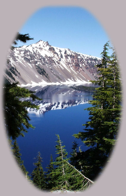
Don't forget Wood River Wetlands and the wildlife refuges of Klamath Basin, nor, quite spectacularly, Crater
Lake National Park. :-)
Travel Oregon and northern California while staying at the retreat near Crater Lake National Park in southern Oregon.
Travel the Rogue Umpqua Scenic Byway to the retreat: Travel Directions Map and Scenery. Experience the grandeur of Toketee, Lemolo & Watson Falls, the beauty of the wild & scenic Umpqua River in the Umpqua National Forest & Crater Lake National Park.
Travel Directions to and Day Trips of about 100 miles from the retreat.
Little known Scenic Places near Crater Lake and the retreat: opportunities to explore, sightsee, photograph nature: hiking trails, sightseeing, wildlife viewing, birding trails, and more: Map & Scenery.
Website Directory for the travel pages Home Page
Page Listings to the travel pages
Contact Brad at Gathering Light ... a retreat.
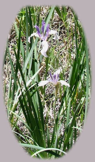
Wild Iris blooming in the flood plain of the Sprague River at the retreat pictured to the right.
|
| |