Traveling the North Umpqua,
| ||||||||||
|
Forward ~ The Umpqua Back ~ Directions to the | |||||||||
|
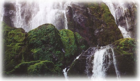
Off the beaten track: The Umpqua's Diversity: Hike to Moon Falls on Layne Creek near Cottage Grove, Oregon. | ||||||||||
|
Protect our National Forests and Wilderness Areas. Leave NO Trace! |
||||||||||
|
Hiking trails are maintained on the Umpqua River Trail. Given no depredations by fire, one can hike the length of the Umpqua from Swiftwater to the headwaters at Maidu Lake. Scenery: page 1 and page 2, the Umpqua River, one of Oregon's wild and scenic rivers. Scenery: page 3, Fern Falls on the Tioga segment of the north Umpqua River Hiking Trail. Scenery: page 4 and page 5, Susan Creek Waterfall on the Rogue Umpqua Scenic Byway. This trail is wheelchair accessible. Scenery: page 6, The hiking trail at Fall Creek, boasts spectacular beauty that seems almost paradisiacal. Scenery: page 7 Fall Creek Waterfall is very beautiful, not in the way of Toketee Waterfall, but still possessing its own grandeur. Certainly, the beauty of the hiking trail contributes to this ... Be sure to go earlier in the year to get the full effect. Scenery on Steamboat Creek, tributary to the North Umpqua River: Little Waterfalls, page 8. You have to walk a few steps; for the most part, however, this waterfall is visible right off the road, and "How High Did You Say the Water Was?" Steamboat Creek, page 9. Steamboat Creek Waterfall in May page 10 and in late summer, page 11. Scenery: page 12, Old Pa on the banks of the wild and scenic Umpqua River in Oregon. Scenery: page 13, the wild and scenic Umpqua River, looking like paradise, at the Medicine Creek trailhead. Scenery: Beautiful and amazing - beyond words - Twin Lakes off the wild and scenic Umpqua River, page 14, page 15, page 16, page 17, page 18, page 19, page 20, page 21, page 22, page 23 and page 24. Scenery: page 25 and page 26, the beautiful hiking trail to Toketee waterfalls. Scenery: page 27 and page 28, exquisite and exceptionally beautiful Toketee Waterfall, on the Umpqua River. Toketee means pretty, graceful in Chinook jargon. The trail is .5 a mile. People I've talked to on the trail have complained about all the stairs, and this trail does go up and down stairs, but I tell you in all honesty, this walk is worth every step. The area around Toketee offers hot springs situated in a covered stone pool right on the canyon of the Umpqua River, Toketee Lake, created in the damming of the Umpqua, a campground, and Toketee Ranger station is close at hand if you have any extraneous questions. Scenery: page 29, beautiful, and as the name implies, crystal clear, Clearwater River. Scenery: page 30, catch a glimpse of the craggy old warrior from the Rogue Umpqua Scenic Byway, Mt Thielsen. Scenery: page 31, the trail to Umpqua Hot Springs, with directions too. Scenery: page 32 and page 33, wild and scenic Watson Waterfalls. Plunging over the steep walls of what almost appears to be an amphitheater, Watson falls is a powerhouse; rated as class 5 waterfall. Scenery: page 34, Watson Waterfall, the forest service rates this hike more difficult. It is a steady climb. Scenery, page 35, Whitehorse Waterfalls, easily viewed from a platform accessible in the parking lot. Find picnic tables, a campground and tank toilets here as well. Scenery: page 36, Clearwater Waterfalls has a charm all its own. It's one of my favorites although Brad doesn't appreciate it in the way I do. I have driven along the Umpqua Scenic Byway more times than I can count, and I always stop to take a look at these falls. The forest ... the way the light falls, the clear flowing stream ... and then there's the waterfall. The waterfall offers a small picnic area and an unimproved campground, meaning there's no water. The roads used to be pretty bad, but the Forest Service had them repaired. There are only 5 or 7 campsites, as well. :-) Scenery: page 37, Lovely WarmSpring waterfalls, shaped by columnar basalt as Toketee Falls are. Be careful walking up to the edge, there is no wall, but there is a Cliff! Scenery: page 38, Lemolo waterfalls. Like toketee and umpqua, lemolo has a unique meaning in Chinook jargon: wild and untamed. This waterfall lives up to its name. The hike is rated more difficult with a steady downhill climb that requires and uphill climb to get back out again. No matter, this is an amazing waterfall. Scenery: page 39, Lemolo Lake, but really a reservoir. Lemolo Lake offers many campgrounds, fishing, a resort - Mt Thielsen peaks up in the background too. Camping in the Umpqua National Forest & those areas managed by the BLMDirections to campgrounds in the Diamond Lake District of the Umpqua National Forest. Directions to campgrounds in the North Umpqua River district. The campgrounds for both districts are off the Rogue Umpqua Scenic Byway, many are on the wild and scenic Umpqua River. All fall between the north entrance to Crater Lake National Park and I-5 at Roseburg, Oregon. Boulder Flat is the last one in the North Umpqua district. After that you're in the Diamond Lake District. Directions to campgrounds in the Little River watershed of the North Umpqua River. Directions for camping facilities in the Row River watershed of the Umpqua River. Directions to campgrounds on the south Umpqua River also in the Umpqua River watershed. Hiking Trails in the Umpqua River watershed in the Umpqua National Forest:Directions for hiking trails to waterfalls and other points of interest in the Row River Watershed of the wild and scenic Umpqua River in the Umpqua National Forest. As well as Directions for the Umpqua River Trail - 12 hiking trails riverside. Directions for hiking trails to the many waterfalls on the wild and scenic Umpqua River off the Rogue Umpqua Scenic Byway. Directions for hiking trails in the south Umpqua watershed. Directions for hiking trails in the Little River watershed. Most within the magnificent Umpqua National Forest. | ||||||||||
|
Travel Oregon and northern California while staying at Gathering Light ... a retreat | ||||||||||
| ||||||||||
|
Contact Brad at Gathering Light ... a retreat. | ||||||||||